Tomb of nabi Bulus (Paul the Apostle)
مقام النبي بولس
קבר נבי בולוס
“Nabi Bulus” in Arabic means none other than St. Paul, the hero of Acts and the author of fourteen epistles from the New Testament. It is believed that Muslims hate Paul for misrepresenting the true teachings of Prophet ‘Isa, i.e. Jesus Christ, and instead of the true religion of Allah, preached by ‘Isa ibn Maryam, created Christianity. Modern Muslims may think so, but their ancestors thought differently. In the Middle Ages Muslims revered Paul as one of the prophets. A prominent Islamic scholar Ibn Kathir (1301–1373), for example, in his interpretation of the Quran mentioned messengers Shamoun (Simon-Peter), Yuhanna (St. John) and Bulus (Paul) as faithful followers of Prophet ‘Isa. Speaking about Bulus, Ibn Kathir pointed out that he preached in Antakya (Antioch of Syria). It is clear that information about Bulus-Paul Islamic scholar learned from church tradition.

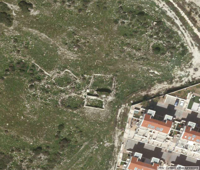
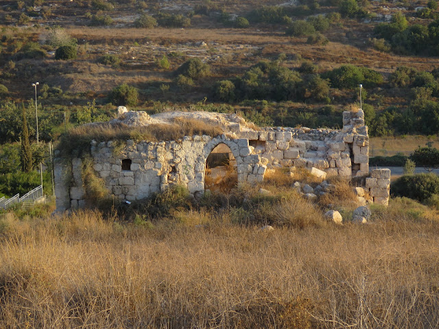
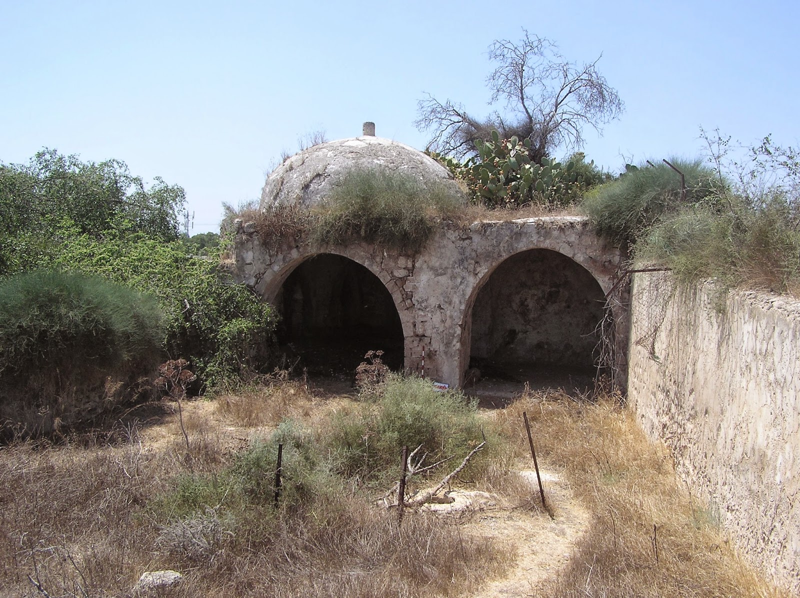
The tomb is located to the south from Beit Jimal Monastery and is directly adjacent to residential areas in Ramat Beit Shemesh. It can be clearly seen from the Highway leading to the interchange Beit Shemesh Darom. Structure consists of the tomb itself, 4.5 x 12.6 m (rooms A and B), and the Prayer hall (mosque), 6.4 x 12.6 m (room C). Under the Prayer hall there is quite a spacious storage with a pointed vault. A Burial chamber is crowned with a small dome. Not so long ago a stone cenotaph of nabi Bulus could be found in the tomb (A. Petersen still had a chance to look at it in 1994); but now it is not there, though one can easily identify the spot on the floor where it was standing.
In the religious complex were from the north, through the central arch. So the room B can be considered as a hallway or living room, from which one can get into the Burial chamber (A) and the Prayer hall (C).

.jpg)

According to the Western Christian tradition, Paul was beheaded in Rome and buried in the same city. Recently under the altar of the Roman Temple of San-Paolo-Fuori-le-Mura a sarcophagus with fragments of human bones, in which they saw the remains of the great “Apostle to the Gentiles”, was opened. However, the Muslim tradition holds that Paul died in Palestine and was buried in the Holy Land. Khirbet an-Nabi Bulus – a small hill, where the concerned tomb is situated – has long been known.
It is noted by E. Robinson, E. Smith and other travelers of the first half of the 19th century. V. Guérin in Description géographique, historique et archéologique de la Palestine says: “This Muslim tomb should be better called the sanctuary or a small Christian Monastery in honor of St. Paul. Anyhow, the wall surrounding it, judging by its remains, was partly built of blocks of pre-Islamic era” (Judee II 374).
C. Conder in his The Survey of Western Palestine gives the description of the tomb: “Heaps of stones round a Kubbeh. The latter is modern, with a cenotaph and a vault below, which looks like Crusading work, and is entered by a door on the west having a lintel with an ornamented boss. North of this building is a fine birkeh. The site has evidently been that of a small village” (SWP III 123).

Next researchers shared the views of V. Guérin and C. Conder. A. Petersen, said though that “In view of the pointed form of the vault, it is more likely that it is a medieval construction (i.e. post Byzantine)." (2001, 226)


In 1999, the archaeological excavations were carried out to the north of the tomb; traces of this are now no longer visible. They found pottery and other artifacts dated to the period of the Abbasid and Mamluk. As well as the remains of the cistern, about which V. Guérin and C. Conder were talking. Its construction dates back to the same period. The important thing is that archaeologists didn’t find anything that belonged to the Byzantines, the Crusaders, and Christians in general. From this point of view the assumption of V. Guérin and C. Conder about the existence of a Christian monastery here is doubtful. Therefore, identifying this place as a burial place of nabi Bulus (St. Paul), Muslims relied on their own tradition.


The tomb is located to the south from Beit Jimal Monastery and is directly adjacent to residential areas in Ramat Beit Shemesh. It can be clearly seen from the Highway leading to the interchange Beit Shemesh Darom. Structure consists of the tomb itself, 4.5 x 12.6 m (rooms A and B), and the Prayer hall (mosque), 6.4 x 12.6 m (room C). Under the Prayer hall there is quite a spacious storage with a pointed vault. A Burial chamber is crowned with a small dome. Not so long ago a stone cenotaph of nabi Bulus could be found in the tomb (A. Petersen still had a chance to look at it in 1994); but now it is not there, though one can easily identify the spot on the floor where it was standing.
In the religious complex were from the north, through the central arch. So the room B can be considered as a hallway or living room, from which one can get into the Burial chamber (A) and the Prayer hall (C).
Plan of the tomb (from the book of A. Petersen)

Photo by H. Berger of 1930s

Photo of 1994. View from the north (from the book of A. Petersen)

According to the Western Christian tradition, Paul was beheaded in Rome and buried in the same city. Recently under the altar of the Roman Temple of San-Paolo-Fuori-le-Mura a sarcophagus with fragments of human bones, in which they saw the remains of the great “Apostle to the Gentiles”, was opened. However, the Muslim tradition holds that Paul died in Palestine and was buried in the Holy Land. Khirbet an-Nabi Bulus – a small hill, where the concerned tomb is situated – has long been known.
It is noted by E. Robinson, E. Smith and other travelers of the first half of the 19th century. V. Guérin in Description géographique, historique et archéologique de la Palestine says: “This Muslim tomb should be better called the sanctuary or a small Christian Monastery in honor of St. Paul. Anyhow, the wall surrounding it, judging by its remains, was partly built of blocks of pre-Islamic era” (Judee II 374).
C. Conder in his The Survey of Western Palestine gives the description of the tomb: “Heaps of stones round a Kubbeh. The latter is modern, with a cenotaph and a vault below, which looks like Crusading work, and is entered by a door on the west having a lintel with an ornamented boss. North of this building is a fine birkeh. The site has evidently been that of a small village” (SWP III 123).
View from the north

View from the west

View from the east

V. Guérin was inclined to attribute the beginning of the construction of this monument to the Byzantine period, and C. Conder – to the time of the Crusades. However, they both ascribe its construction to the Christians. In this case, it is difficult to imagine that Christians would place the burial place of the Apostle Paul here ignoring the tradition of the Church, which states Rome as his death place. The only option remaining is to believe that this building became the Tomb of nabi Bulus later, when the Muslims took possession of it. Perhaps, according to the assumption of V. Guérin, Muslim's notion of the matter was influenced by the fact that a Christian monastery that once existed in this place was named after Apostle Paul.
Next researchers shared the views of V. Guérin and C. Conder. A. Petersen, said though that “In view of the pointed form of the vault, it is more likely that it is a medieval construction (i.e. post Byzantine)." (2001, 226)
Entrance to the Burial chamber

Dome of the Burial chamber

Entrance to the Prayer hall

In 1999, the archaeological excavations were carried out to the north of the tomb; traces of this are now no longer visible. They found pottery and other artifacts dated to the period of the Abbasid and Mamluk. As well as the remains of the cistern, about which V. Guérin and C. Conder were talking. Its construction dates back to the same period. The important thing is that archaeologists didn’t find anything that belonged to the Byzantines, the Crusaders, and Christians in general. From this point of view the assumption of V. Guérin and C. Conder about the existence of a Christian monastery here is doubtful. Therefore, identifying this place as a burial place of nabi Bulus (St. Paul), Muslims relied on their own tradition.
Video 2018
Now the tomb of the person, to whom Christianity owes its triumph, is in an neglected condition, filthy condition. Local residents, who inhabit Ramat Beit Shemesh, use it as a dump and a toilet. Judging by the pictures of the 1930s and photographs in the book by A. Petersen the monument goes to ruin rapidly. A large arch collapsed in front of room B and so did the ceiling of the Prayer hall (C). Further destruction is a threat to the tomb.
Visited: 29.07.12; 15.08.18
Coordinates: 31°42'51.2"N 34°58'51.2"E
Location of the object on Google Maps
References: Robinson 1841, III 17; Tobler 1859, 120; Guérin, Judee II 374; Quarterly statement, III 94; SWP III 24, 123; Palmer 1881, 309 (Sheet XVII); Petersen 2001, 226
Hadashot Arkheologiyot; Hadashot Arkheologiyot
Tomb of nabi Haidar
مقام النبي حيدر
קבר נבי חיידר
There are Umm Jina ruins (Hebrew: Hurvat Gannin) to the west from Beit Shemesh and to the south from Yishi moshav. In 1863 V. Guérin who was in this little settlement when there were 40 families, did not mention any sanctuaries/this/the sanctuary (Judee II 28-29). But it was Ch. Clermont-Ganneau who noticed in 1874, “At Umm Jina there is the sanctuary of Nabi Heidar (is one of the names of the lion in Arabic)” (ARP II, 204). In SWP III 127 “Kubbeh called Sheikh Heider” is mentioned, which stands among heaps of stones and ancient foundations. On the detailed British map of 1942 the tomb of nabi Heidar on Khirbet Umm Jina. It Is obvious that one sanctuary is meant though called differently: “sheikh” or “nabi”.
View from the north

Now this structure is quite in ruins: a part of the eastern wall collapsed, the north wall near the entrance to the tomb is badly damaged. Here, near the entrance, the facing patches which strengthened the wall, are partly saved. A spacious inner yard is adjacent to the tomb from the north; now only the basis of the tomb is left.
Northern wall

The tomb itself is 7 х 7 m, with a small dome; each wall is decorated with vaulted bays. In the south wall there is just a 1,70 m high rounded mihrab. There are no signs of cenotaph. The walls bear Arabic and Hebrew inscriptions.
Southern wall

Route. You may reach Hirbet Umm Jina from Highway 38 through moshav Yishi. You cannot enter the moshav during Sabbath by car, but on foot.
Coordinates: 31°44'51.5"N 34°57'48.3"ELocation of the object on Google Maps
References: Guérin, Judee II 28–29; Clermont-Ganneau, ARP II 204; SWP III 127
Tomb of nabi Jibrin (prophet Gabriel)
مقام النبي جبرين
קבר נבי ג'יברין
The most revered sanctuary of the former Palestinian village Beit Jibrin has survived to the present day. It is located on the entry to the Beit Guvrin National Park and is well seen from Highway 35 at the crossroads of Guvrin. Describing this construction, A. Petersen names it the sheykh's tomb and does not tell the name of the buried person. Since old times this structure has been known as the tomb of nabi Jibrin (i. e. prophet Gabriel). C. Conder presented the case as follows: “The present name, Jibrin, was thought by the Crusaders to have some connection with the angel Gabriel, and they seem to have erected a church to St. Gabriel, of which only the north aisle remains, though the site is still remembered by the peasants, who there venerate a piece of open ground, which probably marks the old nave, and is now dedicated to Nabi Jibrin, "the Prophet Gabriel"” (1879, II 150).


Photo by H. Berger (1930s)

The entrance to the tomb from the northern side, there are two windows along sides from the entrance. Here is the description of A. Petersen: The interior of the tomb is roofed with a domical vault (i.e. no squinches or pendentives) and there are small niches in the west and east walls. In the north-west corner is a rectangular hole which marks the position of a (now destroyed) cenotaph. The most interesting feature of the interior are the wall paintings executed in red henna. These occur on all four interior walls and traces can be also found on the exterior around the east window. Designs include trees, wavy lines, and a variety of abstract forms” (2001, 122).
View from the north-east

View from the east

View from the west

View from the south-west

We can see the same nowadays. Let’s specify, however, that a cenotaph stood not in the north-western but in the south-western corner. Right here there is a corresponding cavity in the floor. It should also be noted that there is no mihrab in the tomb.
Photo of 1994 (from the book of A. Petersen)

Interior. South wall

Interior. South-west corner


Until recently the Muslim shrine has been in neglected condition. An almond tree twined with ephedra (Ephedra foeminea) grew on the tomb’s dome. Quite recently administration of the Beit Guvrin National Park took care to give a decent appearance to the ancient monument. The almond tree was cut down (a protruding stub remained from it), besides, bushes which threatened to absorb the tomb were removed.
Visited: 31.07.12
Coordinates: 31°36'24.6"N 34°53'39.6"E
Location of the object on Google Maps
References: Quarterly statement IX 98; Clermont-Ganneau, ARP II 440; Conder 1879, II 150; II 219; SWP III 271, 294; Palmer 1881, 377 (Sheet XX); Canaan 1927, 285; Petersen 2001, 122
Tomb of nabi Kifl
مقام النبي كفل
קבר נבי כיפל
Impressive structure (8.85 x 10.05 x 3.15 m) with two domes near moshav Tirat Yehuda is called the tomb of Prophet Kifl. The north side of the building is adjacent to the large courtyard with a wall and ruins of some other structures. A stone staircase attached laterally leads to the roof of the building.
Prophet Dhu'l Kifl is mentioned in the Quran (21:85). According to most researchers he is the Old Testament prophet Ezekiel. And according to T. Canaan the shrine of nabi Kifl was known as an important shrine and traditionally had a festival on the 14th day of the Islamic month of Sha‘ban (1927, 215; Petersen 2001, 227).


View from the north-west

View from the north

View from the south

To enter the sanctuary one has to walk through a low rectangular door on the north side. As A. Petersen noted, it seems, however, that the doorway is a later insertion and that originally there was a wide-open arch (2001, 228). The building itself is divided into two adjacent vaulted chambers, or iwans, separated by two arches. Each chamber is crowned by a dome. In 1994, A. Petersen saw in the chamber on the left-hand side (east) the broken remains of a cenotaph. Not a trace of them remained. It is worth noting that if the cenotaph stood at the entrance of the first chamber, in which there is no mihrab, such location of the cenotaph is very unusual for Muslim shrines.
In the south wall of the second room there is a mihrab, which, according to the same researchers, is entirely covered with symbolic paintings in red henna. The motifs used include crescent moons, stars, suns, triangular latticework, and forms resembling the finials used on domes or banners (Ar. ‘alani) (Petersen 2001, 228). Now most of those drawings are erased, and the mihrab current Arab pilgrim have left their own inscriptions.
The mihrab

The domes

View from the east (Courtesy of Israel Antiquities Authority)

Plan of the tomb (from the book of A. Petersen)

Photo of 1990s

Route. From the Road 4613 take the turn to Tirat Yehuda.
Visited: 02.08.12
Coordinates: 32°00'25.7"N 34°55'35.8"E
Location of the object on Google Maps
References: SWP II 269; Palmer 1881, 216 (Sheet XIII); Stewardson 1888, 131; Canaan 1927, 215; Petersen 2001, 227–229; The Archaeological Survey of Israel
Tomb of nabi Sawarka
مقام النبي سراقة
מקאם נבי סוארכה
Vehicles driving along Highway 55 almost brush against the walls of this modest building. Its current name is the Tomb of prophet Sawarka. C. Conder’s Tent Work in Palestine (1879, I, 231) and the old maps state that nabi Serakah was located here. A sacred tree once grew near the tomb, but now not a trace of it remains. According to some reports, it is the tomb of the Bedouin Sheikh from Negev named nabi Serakah or Sawarka (Suwarka) (NIG 2001, VII 94). It is believed that the building dates back to the Mamluk period. The construction is surrounded by the remains of Ottoman period cemetery. The archaeological excavations have found here artifacts from different eras, starting with the Roman-Byzantine (Hadashot Arkheologiyot).


View from the east

The tomb's interior

In 1991, A. Petersen saw a large crack running through the west side of the building (2001, 235). The photo in his book shows that the dome of the tomb, standing on an octagonal drum, was once white. The current structure, as we can tell from the presence of concrete in the masonry, is a re-built tomb. In 2011, the dome and the lintel (top crossbeam above the entrance) are green. Probably the stone cenotaph of prophet Sawarka was also covered with green cloth, but now the covering is gone. In 1991, A. Petersen noted that a rectangular cenotaph was lying along the west wall; but currently the cenotaph is lying along the north wall.
Photo of 1991 (from the book of A. Petersen)

On the other side of the Highway opposite the tomb of the Bedouin sheikh there is a Tomb of Benjamin – a former Muslim shrine now privatized by the Jews.
Tomb of nabi Yamin 1926

Tomb of nabi Serakah (Sawarka) and Tomb of nabi Yamin (Benjamin)
Photo of 1991 (from the book of A. Petersen)

Tomb of Benjamin

Visited: 02.08.12
Coordinates: 32°10'45.2"N 34°56'40.8"E
Location of the object on Google Maps
References: Conder 1879, I 231; Palmer, 1881, 188 (Sheet XI); Stewardson 1888, 132; Clermont-Ganneau, ARP II 339–340; Petersen 2001, 235; NIG 2001, VII 94
Wikipedia: Tomb of Benjamin; The Archaeological Survey of Israel; Hadashot ArkheologiyotAddition: Panorama 1; Panorama 2
Tomb of nabi Shit (Prophet Seth)
مقام النبي شيت
קבר נבי שת
The Muslim name “Shit” reproduces the Biblcal “Seth” – the son of Adam bore this name. The Muslims well worship this patriarch and built up a magnificent tomb in village Bashshit (now within the Israeli settlement Aseret). In fact, Bashshit means Beit ash-Shit – “the dwelling of Shit”.

Photo by H. Berger (1931)

When visiting Bashshit in 1874, a Russian traveler A. Olesnitsky noted, “there is a pond and a mosque glittering with its white domes and made of an ancient material” (II 184). Of course, the tomb of nabi Shit. C. Conder also commented, “A moderately large village of mud, with a large kubbeh having three domes (Nebу Shit) on the higher ground immediately north. It has gardens with cactus hedges, and a masonry well to the south” (SWP II 409 ). It is worth mentioning, there are still cactus bushes around the tomb. It was V. Guérin who wrote about these cactus hedges in the settlement, but he did not mentioned about the tomb of nabi Shit (Judee II 66). He might have passed it by. Though another French traveler, L. Gautier described this tomb as an elegant three-domed wely (1898, 94–95).
View from the east
Dimensions are tombs (11 x 9 m) that A. Petersen also calls it a mosque. He describes it as follows: “The mosque, known as Nabi Shit, stands on the side of a hill in the centre of the former village Bashshit. It is an 'L'-shaped building with a long rectangular courtyard to the east. At the west end of the courtyard is an arcade of three vaulted bays, two in front and one behind. Two of the bays are domed whilst the third bay (on the north-east side) is roofed with a cross-vault. The north wall of this bay contains a small blocked window. To the south are the two domed bays, both with south-facing windows. The south-east bay also has a mihrab and a fixed minbar set into the south wall. A doorway at the back of the south-west bay opens into a small dar room covered with a tall dome. In the south wall of this room is a very shallow mihrab. Externally both mihrabs are visible as conical buttresses. The location of the tomb of Nabi Shit is not clear although it seems likely that it was in the inner room.
The age of the building is unknown although it certainly dates to before the mid nineteenth century. The present structure is not likely, however, to be much older than the sixteenth century although the shrine itself may be more ancient” (2001, 110).


Now the sanctuary wallows in the bushes, inside it there is a batman kingdom. They cover the inner side of the domes, and the floor is covered with stinking excrement. But what scares most is the horrible squeak of winged creatures. A. Petersen says nothing about bats; probably, they settled on this building not long ago. However, no other destructions of the monument are visible.


In the yard adjacent to the eastern well there is a deep dried out well.
Route. South to Yavne there is an Israeli settlement Aseret, on the place of Palestinian village Bashshit. The Muslim shrine is in the centre of the settlement, in cactus hedges.
Coordinates: 31°49'28.3"N 34°44'54.5"E
Location of the object on Google Maps
References: Guérin, Judee II 66; Olesnitsky 1878, II 184; SWP II 409 ; Palästina-Vereins II 144; Palmer, 1881, 272 (Sheet XVI); Stewardson 1888, 132; Clermont-Ganneau, ARP II 184; Gautier 1898, 94–95; Khalidi 1992, 362; Petersen 2001, 110; The Archaeological Survey of Israel

Jewish start to worship his tomb as their sanctuary, but no privatization have been done so far. It is not mentioned in the popular jewish collection “Holly places and tombs of righteous men in Israel” 2000 (on Hebrew). According to the impressive size of the building, it is thought to be set as a sanctuary above the tomb. In 1996 excavations were carried out in the immediate vicinity of the shrine, these revealed substantial buildings associated with pottery datable to the late Mamluk or early Ottoman period.

Petersen who explored the building in 1991, described it as follows, “The building comprises a large domed chamber with two side vaults. The floor level of the interior is nearly lm below ground level suggesting that the shrine is of some antiquity. Before 1948 there was a Qur'anic inscription (Sura 2, V. 256) in the crown of the dome. Unfortunately since then, the dome has more than half collapsed destroying the inscription and exposing the interior to the elements. Although still standing, the building requires urgent conservation.
The interior maybe divided into three areas; the central domed area, and two vaulted aisles arranged east and west of the central domed area. The entrance to the building is through a door in the middle of the north wall of the central chamber. Directly opposite the door in the south wall is the mihrab and next to it are two stone steps which form the minbar. The mihrab is a deeply recessed concave niche with no decoration, it is visible externally as a rectangular projection from the south wall.
The dome rests on a circular collar (diameter 6.2 m) supported by an octagonal drum. The octagonal drum is made up of alternating squinches and blind arches. Above the drum are smaller squinches at the junction between each side, which transform the octagon into a circle. The full height of the dome was 8.5 m above ground level. Originally there was a fragment of marble column which formed the finial of the dome; this feature is no longer visible. Each of the side aisles consists of two cross-vaulted bays with a single pier on the side facing the interior. In the south bay of the west aisle is a fragment of marble column marking the grave of Nabi Thari” (2001, 232–233).


If, as A. Petersen ed, one could enter the building through the door in the middle of the northern door in the central hall, then this doorway was obviously laid quite a long time ago.
In 1991, the construction was already in great need of conservation. However, the abandoned sanctuary is still destroying. There is a beegarden and farmlands near it.
Route. The sanctuary is located near Route 471, between the crossroad of Sha'ariya and Nahshonim junction.
Visited: 15.08.15
Coordinates: 32°04'02.6"N 34°55'31.4"E
Location of the object on Google Maps
References: Robinson 1856, 141; Finn 1867, 136; Guérin, Samarie II 389; SWP 1881, 41; SWP II, 269; Palmer 1881, 217 (Sheet XIII); Stewardson 1888, 132; Canaan 1927, 295; Petersen 2001, 232–233; The Archaeological Survey of Israel; iNature

Dimensions are tombs (11 x 9 m) that A. Petersen also calls it a mosque. He describes it as follows: “The mosque, known as Nabi Shit, stands on the side of a hill in the centre of the former village Bashshit. It is an 'L'-shaped building with a long rectangular courtyard to the east. At the west end of the courtyard is an arcade of three vaulted bays, two in front and one behind. Two of the bays are domed whilst the third bay (on the north-east side) is roofed with a cross-vault. The north wall of this bay contains a small blocked window. To the south are the two domed bays, both with south-facing windows. The south-east bay also has a mihrab and a fixed minbar set into the south wall. A doorway at the back of the south-west bay opens into a small dar room covered with a tall dome. In the south wall of this room is a very shallow mihrab. Externally both mihrabs are visible as conical buttresses. The location of the tomb of Nabi Shit is not clear although it seems likely that it was in the inner room.
The age of the building is unknown although it certainly dates to before the mid nineteenth century. The present structure is not likely, however, to be much older than the sixteenth century although the shrine itself may be more ancient” (2001, 110).

Plan of the tomb

Now the sanctuary wallows in the bushes, inside it there is a batman kingdom. They cover the inner side of the domes, and the floor is covered with stinking excrement. But what scares most is the horrible squeak of winged creatures. A. Petersen says nothing about bats; probably, they settled on this building not long ago. However, no other destructions of the monument are visible.
View from the south

Interior

The mihrab

In the yard adjacent to the eastern well there is a deep dried out well.
Route. South to Yavne there is an Israeli settlement Aseret, on the place of Palestinian village Bashshit. The Muslim shrine is in the centre of the settlement, in cactus hedges.
Coordinates: 31°49'28.3"N 34°44'54.5"E
Location of the object on Google Maps
References: Guérin, Judee II 66; Olesnitsky 1878, II 184; SWP II 409 ; Palästina-Vereins II 144; Palmer, 1881, 272 (Sheet XVI); Stewardson 1888, 132; Clermont-Ganneau, ARP II 184; Gautier 1898, 94–95; Khalidi 1992, 362; Petersen 2001, 110; The Archaeological Survey of Israel
Tomb of nabi Thari (Asher son of Jakob)
مقام النبي ﺛﺂﺮﻱ
קבר נבי ת'ארי
All the twelve sons of Jacob, the ancestors of Tribes of Israel, are worshipped as prophets in Islam. Religious buildings were constructed in different parts of Palestine in honour of them. Asher son of Jakob), is known as prophet Thari. The researchers of the 19 century cal him nabi Thary or nabi Tari.


Jewish start to worship his tomb as their sanctuary, but no privatization have been done so far. It is not mentioned in the popular jewish collection “Holly places and tombs of righteous men in Israel” 2000 (on Hebrew). According to the impressive size of the building, it is thought to be set as a sanctuary above the tomb. In 1996 excavations were carried out in the immediate vicinity of the shrine, these revealed substantial buildings associated with pottery datable to the late Mamluk or early Ottoman period.
The Plan of sanctuary and its reconstruction (from the book of A. Petersen)

Petersen who explored the building in 1991, described it as follows, “The building comprises a large domed chamber with two side vaults. The floor level of the interior is nearly lm below ground level suggesting that the shrine is of some antiquity. Before 1948 there was a Qur'anic inscription (Sura 2, V. 256) in the crown of the dome. Unfortunately since then, the dome has more than half collapsed destroying the inscription and exposing the interior to the elements. Although still standing, the building requires urgent conservation.
The interior maybe divided into three areas; the central domed area, and two vaulted aisles arranged east and west of the central domed area. The entrance to the building is through a door in the middle of the north wall of the central chamber. Directly opposite the door in the south wall is the mihrab and next to it are two stone steps which form the minbar. The mihrab is a deeply recessed concave niche with no decoration, it is visible externally as a rectangular projection from the south wall.
The dome rests on a circular collar (diameter 6.2 m) supported by an octagonal drum. The octagonal drum is made up of alternating squinches and blind arches. Above the drum are smaller squinches at the junction between each side, which transform the octagon into a circle. The full height of the dome was 8.5 m above ground level. Originally there was a fragment of marble column which formed the finial of the dome; this feature is no longer visible. Each of the side aisles consists of two cross-vaulted bays with a single pier on the side facing the interior. In the south bay of the west aisle is a fragment of marble column marking the grave of Nabi Thari” (2001, 232–233).
View from the south-east

View from the west

Inside the building

Inside the building

The mihrab

A fragment of marble column marking the grave of nabi Thari

The northern door in the central hall

If, as A. Petersen ed, one could enter the building through the door in the middle of the northern door in the central hall, then this doorway was obviously laid quite a long time ago.
In 1991, the construction was already in great need of conservation. However, the abandoned sanctuary is still destroying. There is a beegarden and farmlands near it.
Route. The sanctuary is located near Route 471, between the crossroad of Sha'ariya and Nahshonim junction.
Visited: 15.08.15
Coordinates: 32°04'02.6"N 34°55'31.4"E
Location of the object on Google Maps
References: Robinson 1856, 141; Finn 1867, 136; Guérin, Samarie II 389; SWP 1881, 41; SWP II, 269; Palmer 1881, 217 (Sheet XIII); Stewardson 1888, 132; Canaan 1927, 295; Petersen 2001, 232–233; The Archaeological Survey of Israel; iNature
Isareal is a holy place for all the Jews, Muslims and Christians of the world. It is a house to many Holy prophets. Thanks for sharing the pictures of their tombs!
ReplyDeleteHave you read what the Bible says about this Land, and who God have it to? Have you thought about what the words Land OF ISRAEL mean?
DeleteI found that site very usefull and this survey is very cirious, I ' ve never seen a blog that demand a survey for this actions, very curious... 2 Month Anniversary Paragraph For Her
ReplyDeletePositive site, where did u come up with the information on this posting? I'm pleased I discovered it though, ill be checking back soon to find out what additional posts you include. marabout brest
ReplyDeleteyour content is so unique and fascinating! keep up the good work. I don't remember how I discovered your blog today, but I learned so many interesting things about the Maqam culture in Palestine and the biblical Judeo-Christian prophets. It's really sad to see the state of such places of much historical and cultural significance. I wonder the battle of colours is still going on among the settlers and the locals tho!
ReplyDelete